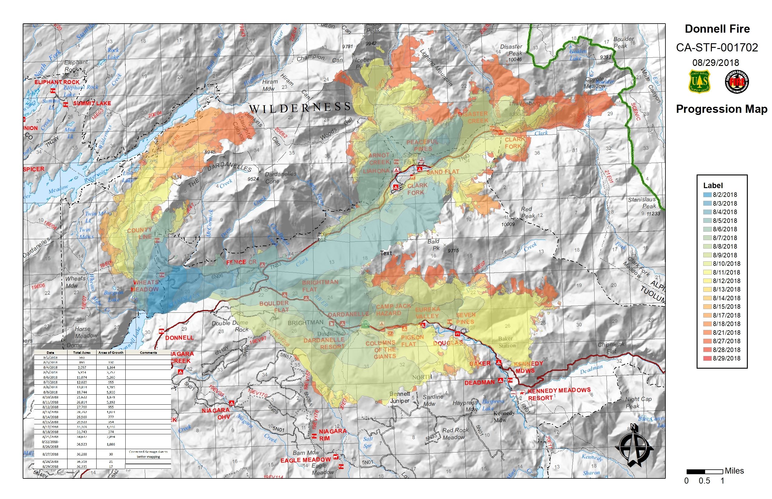
Donnell Fire Summary Timeline
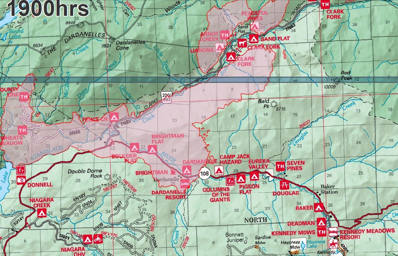
The Donnell Fire started Wednesday, Aug 1st near the east side of Donnell Lake at 7:49 p.m. it destroyed 54 structures, 81 outbuildings and burned 36,450 acres or almost 57 square miles (147.5 sq km). The cause, detailed here was an escaped unattended campfire. The fire was fully extinguished on December 17, 2018. (Jump to end of the timeline).
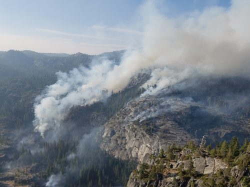
August 2, at 1 p.m.: Air and ground crews are heading to a vegetation fire that was called into the Stanislaus National Forest dispatch. The flames are reported to be burning in Tuolumne County in the area of Donnell Vista, off Highway 108 in the Summit Ranger District. Forest Service spokesperson Diana Fredlund details, “It’s a one to two acre fire in the wilderness near the Donnell Inlet. We are ordering additional resources up to take a look.” Assessments jumped to 30-40 acres in a few hours and to 75 acres by 4 p.m. The fire was reported as running along the Middle Fork Stanislaus River; “The fire consists of a main fire and two spots fires,” details Fredlund. “The spot fires are about a quarter mile up the stream from the main fire. Everything is on the north side of the river.” The fire was 350 acres and evacuation advisory for the Wagner Housing tract and Clark’s Fork and Camp Liahona in Clark Fork was issued. A helicopter used water from Lake Donnell, more resources to arrive Friday morning. Fredlund “We are waiting for the hotshots to come in as they’re the ones trained to do it.” Day one details here.
Aug 3, Day 3: 400 acre Donnell Fire burning in the Stanislaus National Forest. Fredlund notes that two hotshot crews, which each have anywhere from 18-21 firefighters, have arrived at the incident. “One hotshot crew is from the Stanislaus, and the other is the El Cariso hotshots from the Cleveland National Forest (Southern California).” 30 structures are considered threatened.
5:15 p.m. 600 acres, Mandatory evacuations have been ordered by the Tuolumne County Sheriff’s Office for the areas of Wagner Tract, Clark Fork Road, Camp Liahona and Sand Flat. There are 30 structures threatened and a total of 165 personnel on the scene.
Aug 4, Day 4: 600 acre to 1,500 Donnell Fire. Fredlund details, “During morning hours the fire is under an inversion and actively burning in timber and brush, with movement driven primarily by terrain. Once the inversion lifts around noon, the canyon winds increase to 25 mph and that causes the fire to drastically increase its rate of speed.” She explains, “That means Aircraft are restricted in the morning due to smoky conditions and the inversion, but also restricted later in the day due to high winds.”
Fire officials relay that the main strategy is to keep the fire north of the Middle Fork of the Stanislaus River, south of trail 19E06 and east of Dome Rock. Update at 3:05pm: The Tuolumne County Sheriff’s Office has modified its earlier evacuation order. The area between Clark’s Fork campgrounds and the Dardanelles is now under a mandatory evacuation order. Some large air tankers have been spotted near the fire this evening, including a DC-10.
Aug 5, Day 5: 1,750 acres to 6,000 acres and there is no containment. Multiple structures destroyed, unable to be identified by fire crews. Tuolumne County Sheriff’s Office adds Forest Service Road 5N01 to the list that is under a mandatory evacuation order.
Donnell Fire is threatening a combined 225 structures and outbuildings. A mandatory evacuation order remains in place for the area stretching from the Clark Fork campground to the Dardanelles resort. An advisory evacuation notice is in place from Dardanelles to Kennedy Meadows. 65 cabins and five large campgrounds in the Brightman area were evacuated, while 88 cabins, two resorts, and several large campgrounds are under the advisory. Yesterday the fire crossed the Stanislaus River and it has been burning to the northeast. Crews are trying to keep it north of the Middle Fork of the Stanislaus River, south of Spicer, west of Bald Peak and east of Dome Rock. The fire has been burning through roughly two feet high brush, timber litter and understory, according to the forest service.
There is a hard closure of Highway 108 at Eagle Meadow.
Aug 6, Day 6: 6,000 acres to 11,000 with better mapping. Evening Meeting update: The latest size estimate is just over 11,000 acres, but the team on hand stated that they know it is much larger at this point. It may not be until late this evening, or early tomorrow, when a new size estimate is released.
It was emphasized that a “lack of resources” is the most glaring challenge.
Aug 7, Day 7: 13,200 acres, 15 structures destroyed. The Stanislaus National Forest downgraded the size estimate this morning. After earlier indicating that it is up over 13,200 acres, the new size estimate is 11,340 acres, according to Forest Service spokesperson Maria Benech.
Total personnel of 481 assigned to the incident include seven hand crews, three helicopters and 18 engines.
Aug 8, Day 8: The Donnell Fire’s growth was minimal yesterday in the Stanislaus National Forest, but the acreage increased to 13,814 due to better mapping. 1,120 structures are considered threatened and at least 26 have been destroyed. Ending acreage 17,941 and 4-5% contained.
The Tuolumne County Board of Supervisors approved local emergency declaration related to the impacts of wildfires. Details here.
Aug 9, Day 9: More Damage Assessment Completed On 21,097 Acre Donnell Fire, 6% containment. 602 firefighters assigned to the incident. 55 structures have been destroyed along with 81 smaller outbuildings. 220 structures are considered threatened. Updates here.Incident Command is reporting a drop of 1,353 acres in the size of the Donnell Fire in the Stanislaus National Forest making the total acreage 19,744 acres instead of the previous 21,097 reported this morning.
Tuolumne County Declaring Local State Of Emergency Due To Wildfires
Aug 10, Day 10: 23,824 and there is 5-percent containment the US Forest Service issued an order closing the Carson-Iceberg Wilderness and Spicer Lake. Updates are here.
Aug 11, Day 11: 26,814 and there is 14 to 20 percent containment the US Forest Service issued an order closing the Carson-Iceberg Wilderness and Spicer Lake. Moderate fire activity with the fire continuing its path towards Spicer Reservoir to the north, northeast towards Boulder Creek, and east along Highway 108. The flames are skirting above the highway, but have reached within a mile of Kennedy Meadows as earlier reported. Fire crews are also dealing with hazardous trees along the Highway 108 corridor and around structures that have been impacted by the blaze. Updates are here.
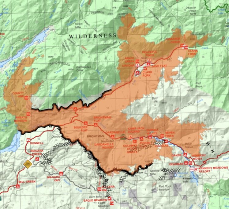
Aug 12, Day 12: 27,769 acres 20 percent containment. The region around the Dardanelle Resort: flames destroyed 14 of 16 cabins in the Wagner Tract, 36 of 57 cabins in the Brightman Tract, 2 of 2 cabins in the Buena Vista Tract, and 1 of 10 cabins in the Bone Springs Tract. Areas with no loss of structures include: Baker Station or within Riverside, Cedar Grove, Deadman, Baker, East Douglas, West Douglas, and Twin Buttes Tracts.
Aug 13, Day 13: 23,302 and there is 20 percent containment. Updates are here. There will be another community meeting where residents can hear the latest on the fire response, and ask questions. It will run from 5-6:30pm at the Word of Life Church in Mi Wuk Village. It is located at 24630 Highway 108.
Aug 14, Day 14: 29,569 acres, 25-percent contained. Hot shot crews have made substantial progress constructing hand line from the Bennett Juniper toward Highway 108 on the easterly edge. In the Eagle Creek drainage crews brought in pumps and hose utilizing water to secure more containment lines. Teams also cut hand line on the northwest edge of the fire. The Forest Service is no longer in unified command with CAL Fire.
Aug 15, Day 15: Forest Service spokesperson Phyllis Ashmead “There is some good news about the southern edge of the fire. The firefighters have been able to add more containment line around the perimeter between the Bennett Juniper and Kennedy Meadows, so that is getting buttoned up. Overall, fire activity has gone down significantly.”
Aug 16, Day 16: The blaze is 30,079 acres and it is 30-percent contained. Dodge Ridge campground photos- resort officials shared that they were granted an escort by fire crews yesterday, to check out Clark Fork and Sand Flat campgrounds, which they continue to operate under a 1982 U.S. Forest Service agreement.
Aug 17, Day 17: 31,369 acres and 36-percent contained. 865 firefighters are on scene, resources include 18 hand crews, five helicopters, 39 engines, two dozers and eight water tenders. The fire has been burning the hottest over recent days north of Spicer Reservoir.
Aug 18, Day 18: Hike in the containment on the Donnell Fire in the Stanislaus National Forest to 42-percent containment, slight growth of 374 acres for a total of 31,743. Highway 108 through the Donnell Fire burn area open between Eagle Meadow and the Tuolumne-Mono county, no stopping from Eagle Meadow and Kennedy Meadows.
Aug 19, Day 19: Donnell Fire is now 31,743 acres and 49 percent contained.
4PM: Highway 108 is back open through the Donnell Fire burn area.
Aug 20, Day 20: 31,743 and 49% contained.
Aug 21, Day 21: 51 percent contained at 35,000 acres as firefighting crews continue to focus on its northeast flank near Spicer Reservoir. The fire gained about another 3,500 acres since Monday, according to incident spokesperson Bob Francis. Permit Holders May Reenter After Safety Inspections Finish
Aug 22, Day 22: Containment jumps to 62-percent overnight and the acreage increases just 288 acres for a total of 35,288. Details here.
Aug 23 Day 23: Forest Service spokesperson Kimberly Petersen “It is still moving in a northeast direction through the drainages in Clark Fork. We do have some movement in the Arnot, Disaster and Boulder creek areas. So, there is still concern about it [the fire] getting to the Pacific Crest Trail.” Details are here.
Aug 24: The latest official figures are 35,288 acres and 62-percent containment. It is important that people are driving through and not pulling over. There are still some hotspots along Highway 108. Details here.
Aug 25: Wind a concern, overnight the blaze grew 396 acres to a total of 35,684 while the containment remains at 62-percent. The area between Donnell Vista and Kennedy Meadows remains under a mandatory evacuation order. Kennedy Meadows, and the road leading to it, are open.
Aug 26: Contracted helicopter pilot makes a hard landing, minor injuries.
Forest Service officials report that a second vegetation fire ignited near the Donnell Fire, dubbed the “Cliff Fire,” ten miles east of the Donnell Fire in the Humboldt-Toiyabe National Forest wilderness. Details here.
Aug 27: The fire closure area remains in effect between Eagle Meadow and Kennedy Meadows where thru traffic only is being permitted along Highway 108. The only areas that are currently open are Kennedy Meadows Resort, including Baker and Deadman campgrounds. The main fire camp has moved to Bear Valley and will be supporting the crews. The satellite camp in Kennedy Meadows remains to support firefighters working on the fire’s southeast area.
The Pacific Crest Trail remains closed between Highways 108 and 4.
Fire Closure Order STF-16-2018-011 remains in effect; under it Highland Lakes Road (Forest Service Road 8N01) is open to Tryon Meadow, Pacific Valley Campground and to the Bull Run Lake access area; however the trail is closed at the Carson-Iceberg Wilderness boundary.
Under Fire Closure Order STF-16-2018-011 closed areas include all residences and campgrounds along Eagle Meadow Road (5N01), the Highway 108 corridor and the Clark Fork Road area. Property owners may obtain permits for access through the Summit Ranger District. Details here.
Aug 28: 604 more acres burned bringing the total to an estimated 36,288 acres, containment up to 63-percent. On the northern and eastern edge of the fire, the Redding Smokejumpers are helping to build and strengthen fire lines.
Aug 29: The Forest Service’s current strategy is being described as “hold, validate and mitigate.” Those battling the Donnell Fire will primarily focus on the northeastern edge today as the blaze continues to move along the Highlands, Arnot and Disaster creek drainages. Details here.
Aug 30: 36,335 acres with 64 percent containment While demonstrating moderate fire behavior, officials report that it grew by just 17 acres yesterday and crews gained one more percent in containment.
Aug 31: Forest Service has started reopening areas that were previously off limits. Details here.
Sep 1 Day 32: Saturday overview/update.
Sep 3 Day 34: No More Structures Threatened By Donnell Fire
Sep 4 Day 35: Boot Fire starts, details here. Donnell Fire now at 36,349 acres, has shown minimal fire growth over the past couple of days and remains at 85 percent.
Sep 5 Day 36: Donnell Fire Containment Holds: Thunderstorms Remain A Threat – The National Weather Service issued a flash flood watch in the vicinity of the Donnell Fire yesterday, and the Burned Area Response Team (BAER) is out today assessing whether there was any resource damage.
Sep 7 Day 38: Over the past week grown 150 acres to 36,400 acres, 87-percent contained.
Sep 8 Day 39: The blaze is holding steady at 36,400 acres and the containment has risen to 87-percent. Pacific Crest Trail is open for public use. Details here.
Sep 9 Day 40: The type 3 Stanislaus National Forest incident command team will transition to a smaller type 4 team. Details here.
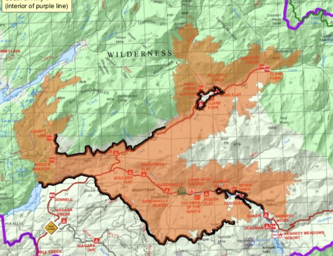
Sep 12 Day 42: Incident officials are calling the Donnell Fire 90 percent contained at 36,450 acres and showing minimal activity. All spur roads heading north off 5N01 will remain closed, spur roads heading south off 5N01 are open. Highland Lakes, Spicer Lake, The Pacific Crest Trail, and Forest Road 5N01 are open for public use. Motorists may use Highway 108 for thru-traffic purposes only.
Sep 14 Day 44: The Donnell Fire is now 90-percent contained and over 36,000 acres. Map of the new forest closure order. Some Areas Near Donnell Fire Reopen ahead of hunting season.
Sep 22 Day 52: The acreage estimate remains at around 36,450 and the containment continues to hover at 90 percent. While the area along Highway 108 east of Donnell Vista remains closed for recreating, effective today, the trails and roads south of Forest Road 5N01 are back open. More details here.
Sep 29 Day 59: Campgrounds and day use areas on Highway 108 east of Donnell Vista remain closed, but OHV recreation areas, trails and roads near Niagara Creek are now open to visitors. Trails and areas west of Highland and Weiser creeks on Calaveras Ranger District have also been reopened. This revised closure will be in effect until Dec. 31st or until replaced or rescinded, according to forest service officials. Details here.
October 3: Rebuilding cabins, permits and more.
October 20: Focus On Development, General Plan And Post Donnell Fire, Mother Lode Views audio program here.
2013 Rim Fire Summary and the Calaveras 2015 Butte Fire Summary, also in Mariposa the 2017 Detwiler Fire Summary, 2018 Ferguson Fire Summary
Events
Sonora Farmers Market | 7:30 am - 11:30 am
Sonora Moose Lodge- Yard Sale
Sonora Moose Lodge | 9:00 am - 3:00 pm
Murphys Community Club Homecoming
Murphys Community Park | 11:00 am - 5:00 pm
Sonora Opera Hall | 9:00 am - 9:30 am
Tall Tales, Silly Songs, and Nature Crafts
Pinecrest Amphitheater | 10:00 am - 12:00 pm
Westside Memorial Park | 6:00 pm - 8:00 pm
Music in the Parks
Turner Park | 6:30 pm - 8:00 pm