Day two information about the Oak fire is below, information on the day it started is here, or review day three or day four.
Update at 7:01 p.m: The Oak Fire continues to be very active as it burns into Saturday evening with CAL FIRE updating the acreage to 11,900 acres with zero percent containment.
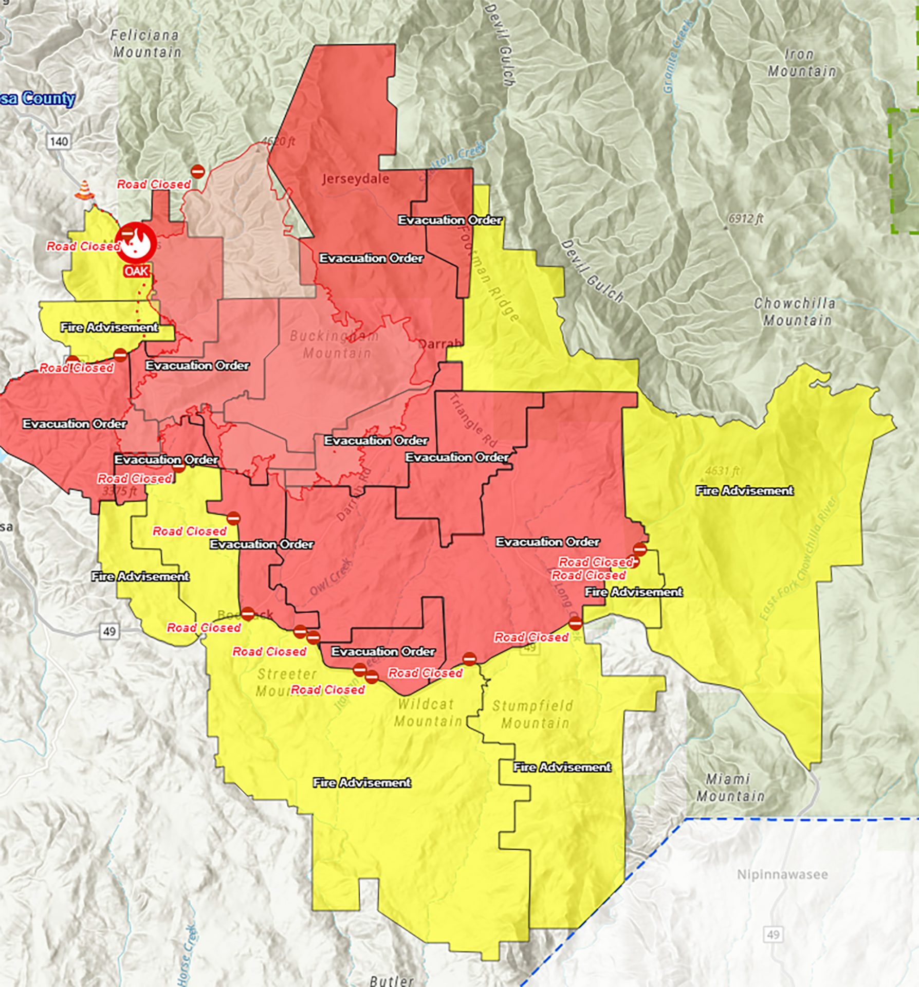
Update at 4:55 p.m: CAL FIRE has updated the acreage and the Oak Fire now stands at 9,500 acres with zero percent containment. The evacuation and road closure map has also been updated and can be found here.
Update at 12:20 p.m: The Mariposa Sheriff’s Office reports that the large animal evacuations shelter at the Mariposa County Fair Ground is not allowing visitations after drop-off. It is not accepting dogs or cats. For specific information regarding large animals, contact Animal Control at 707-484-3556. All the latest Oak Fire information including evacuations and road closures can be found below.
Update at 10:15 a.m.: The Mariposa Sheriff’s Office has released more evacuation orders and advisories along with another road closure for the Oak Fire burning in the Midpines area of Mariposa County. There is zero containment and the fire is 6,555. CAL Fire is reporting this morning that ten structures have been destroyed, five damaged, and there are another 2,000 threatened.
New evacuation orders:
- Allred Rd from Hwy 140 to Morningstar
- West side of Hwy 140 from Triangle to Allred Rd.
New Road Closure:
- Hwy 140 is closed from Grosjean to Ponderosa Way
Evacuation Advisories, meaning residents should prepare to be evacuated at any time, have been issued for the following areas:
- Hwy 140 from Oak Rd to East Whitlock
- Oak Rd from Hwy 140 to Yosemite Oaks
- Yosemite Oaks Rd from East Whitlock Hwy 140
- Chamberlain Rd
- Allred Rd from Hwy 140 to Hwy 49S
- Carlton Rd from Morningstar to Hwy 49S and all side roads
- Hwy 49S from Indian Peak to Triangle Rd
- Indian Peak from Hwy 49S to Usona Rd and all side roads
- East Whitlock from Hwy 140 to Yosemite Oaks Rd
- Stumpfield Mountain Rd from Hwy 49S to the Madera County Line including all side roads
- East Westfall from Oliver Creek to Chowchilla Mountain Rd
- Chowchilla Mountain Rd from 49S to East Westfall
All earlier evacuation and road closure information can be viewed below.
Update at 7:55 a.m.: CAL Fire updates that the Oak Fire burning in the Midpines area of Mariposa County has exploded overnight to 6,555 acres and there remains no containment.
CAL Fire is reporting this morning that ten structures have been destroyed, five damaged, and there are another 2,000 threatened. The fire broke out at 2 o’clock in the 4900 block of Carstens Road, off of Highway 140. CAL Fire reports that the fire activity is extreme with frequent runs, spot fires, and group torching. They added, “Emergency personnel are working to safely evacuate people and are actively engaged in protecting structures. Explosive fire behavior is challenging firefighters.“
Resources on scene include 403 personnel, 45 engines, 11 hand crews, 4 water tenders, 4 dozers, and 4 helicopters. All the evacuations and road closures can be viewed below.
Original post at 5:50 a.m.: Mariposa County, CA — The Oak Fire burning in the Midpines area of Mariposa County is now 4,350 acres and there remains no containment.
The fire broke out in the 2 o’clock hour in the 4900 block of Carstens Road, off of Highway 140. CAL Fire officials gave this update on the fire’s activity overnight: “The fire activity is extreme with frequent runs and group torching. Vegetation is very receptive to new spot fires due to the hot, dry weather and drought. Heavy fuels, strong winds, and low humidity are also influencing fire behavior.”
Evacuation orders remain in place in these areas:
- Carstens Rd
- Buckingham Mt. Rd
- Plumbar Creek Rd
- Triangle from Hwy 140 to Darrah
- Jerseydale and all side roads
- Lushmeadows Subdivision
- Triangle Rd from Darrah Rd to Westfall and all side roads
- Boyer Rd from Hwy 49S and all side roads
- Darrah Rd from the stop light to Triangle Rd
- Triangle Rd from 49S to Westfall Rd and all side roads including Triangle Park
- Tip Top Rd
- Wass Rd
- Westfall from Triangle to Oliver Creek
- Silva Rd from Cole to Triangle including all side roads
- Gingers Trish Rd
- Cole Rd to Darrah Rd including all side roads
- Darrah Rd from Hwy 49S to Triangle Rd including all side roads.
- McNally Rd
- Hwy 49S from Darrah Rd to Triangle Rd East side only. (bootjack market side)
- Woodland Drive
- Brooks Rd
- Carlton from Triangle to Morningstar Lane
- Morningstar from Carlton to Allred Rd- Including all side roads
- Indian Rock Lane
An evacuation center is located at the Mariposa Elementary School located at 5044 Jones St., and Sierra Foothill Charter School at 4952 School House Rd., Cathey’s Valley
Road Closures:
- Hwy 140 from Allred Rd to Ponderosa Way
- Carstens Rd
- Triangle Rd from Hwy 140 to Hwy 49 and all side roads\Buckingham Mt. Rd
- Plumbar Creek Rd.
- Jerseydale Rd
- Silva Road from Cole Road and Triangle Road
- Wass Rd
- Tip Top Rd
- Darrah at Cole Rd
- Westfall from Triangle to Oliver Creek
-
McNally Rd
-
Woodland Drive
-
Brooks Rd
-
Bootjack Lane
-
Cole Rd
An Evacuation Center is open at the Mariposa Elementary School located at 5044 Jones St. that is doubling as a small animal shelter. A large animal shelter at the Mariposa Fair Grounds.
Resources on scene include 383 personnel, 43 engines, 11 hand crews, 3 water tenders, 4 dozers, and 4 helicopters.