The National Weather Service has issued a Flood Warning for small streams in Tuolumne and Calaveras Counties until 6 AM Tuesday.
A Flood Warning has also been issued for urban areas and small streams in southwestern Calaveras County until 6 AM Tuesday.
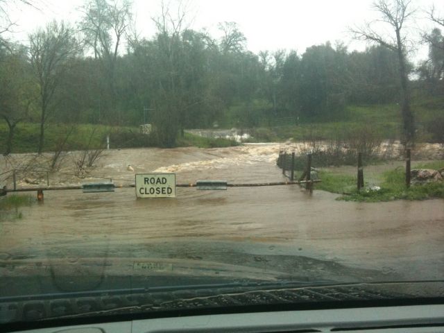
At 9:03 AM this morning, reporting gauges indicate that several streams within the warning area are rising rapidly. Most rivers are expected to crest this afternoon top their banks in many areas.
Over the past 24 hours, a few inches of rain has fallen in the Mother Lode.
Additional rainfall amounts of 3 to 8 inches are forecast in the warning area of the Mother Lode through Monday. Local roadway flooding is likely.
A Flash Flood Watch remains in effect for the Sierra Nevada through Monday afternoon.
A Flood Watch will also continue to remain in effect for the Mother Lode and the Northern San Joaquin Valley through Wednesday afternoon.
This is all due to the Atmospheric River, a narrow corridor of concentrated moisture, that will continue to impact Northern California through Wednesday.
A Wind Advisory for the Mother Lode and the Northern San Joaquin Valley, is also in effect until 6 PM this evening.
And a Winter Storm Watch has been issued for the Sierra Nevada from late tonight through Wednesday afternoon.
The series of wet storm systems will continue to impact Northern California through the middle of next week.
With high snow levels in the Sierra, the combination of heavy rain, snowmelt and runoff may cause serious flooding of rivers and small streams over the higher terrain. Flash Flooding is possible in the vicinity of wildfire burn scars.
Rainfall totals through Wednesday are expected to range from four to six inches in the Central Valley and seven to sixteen inches in the Mother Lode and the Sierra Nevada.
One impact from rain saturated soil are fallen trees along with regional power outages.
Persons living near rivers and small streams should closely monitor water levels this weekend and be prepared to move to higher ground if flooding becomes imminent. If you live in a normally flood prone area, have an evacuation plan ready should flooding become a threat to your home or property.
Avoid driving through unknown depths of water. Turn around, don`t drown. Most flood deaths occur in vehicles.
Colder air will begin to move into the region late tonight and continue into Wednesday.
Total snow accumulations will range from three to seven feet in the Sierra Nevada from Monday through Wednesday.
Hazardous travel is expected with slick roads and low visibilities. Long travel delays are possible due to traffic accidents and snow removal. Chain controls are likely, and road closures are possible.
Winds of twenty to thirty mph ware expected today in the Mother Lode and the Central Valley with gusts ranging from forty to fifty mph.
Some of the impacts could include downed trees, tree branches and power lines. Moderate-sized power outages are possible.
A Flood Warning means that flooding is imminent or occurring. All interested parties should take necessary precautions immediately.
A Flash Flood Watch means that conditions may develop that lead to flash flooding. Flash flooding is a very dangerous situation. You should monitor the later forecasts and be prepared to take action should Flash Flood Warnings be issued.
A Flood Watch means there is a potential for flooding based on current forecasts. Those living in areas prone to flooding should be prepared to take action should flooding develop.
A Wind Advisory means that winds of thirty-five mph are expected. Winds this strong can make driving difficult, especially for high profile vehicles.
A Winter Storm Watch means there is a potential for significant snow, sleet, or ice accumulations that may impact travel.