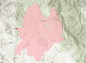
Update at 8:40am: CAL Fire updates this morning that the acreage burned on the Oak Fire is now 18,715 and there is 32 percent containment.
Officials report that firefighters worked overnight to increase containment lines around the fire perimeter. Smoke continued to produce poor visibility across the fire during the night. Temperature and humidity are forecasted to be similar to yesterday. Crews continue patrolling for hot spots, providing structure defense, and building a direct fireline in very steep and rugged terrain. Damage inspection will continue today throughout the fire’s perimeter. Last night, Highway 140 was reopened through Mariposa County to Yosemite National Park, and will remain open contingent upon fire conditions. Fire suppression equipment may be in the area, so use caution in the area.
Original story posted at 6:25am: Mariposa, CA — There was very minimal growth on the Oak Fire in Mariposa County yesterday.
It is 18,532 acres and there is 26 percent containment. Public Information Officer Justin Macomb comments, “All in all, firefighters are out there working hard every day.”
He adds that officials continue to be challenged by the extremely steep terrain. Crews battling the fire were helped by changes in relative humidity and somewhat lower temperatures yesterday as monsoonal moisture moved through the Sierra Nevada foothills. More control lines are being built with support of air and ground resources.
CAL Fire adds, “An infrared flight over the fire showed minimal heat in Lushmeadows and surrounding communities. Crews have been able to hold and improve the fire line in the Mariposa Pines area.”
A notable change is that Highway 140 is back open through Mariposa and Midpines.
Additional evacuation orders were reduced to advisements yesterday. 41 structures have now been destroyed and an additional three have been damaged.
Evacuation Orders
-Carstens Rd
-Buckingham Mountain Road
-Plumbar Creek Rd
-Jerseydale Road and all side roads
-Lushmeadows Subdivision
-Triangle Rd from Hwy 140 to East Westfall including all side roads
-Darrah Rd from Quail Ridge to Triangle Rd including all side roads
-East Westfall Road from Triangle to Oliver Creek including all side
-Silva from Van Ness to Triangle
-Carleton Rd from Indian Rock to Triangle Rd
-Hwy 140 from Triangle Rd to Ponderosa Way (on Midpines Market side of Hwy 140)
-Ponderosa Way including all side roads
-Sweetwater Ridge / Mine area
-Feliciana Mountain Rd
-Ferguson / Apperson Mine Rd area
-Savage Lundy Trail
-Carter Road Including all side roads
-Hites Cove Rd
-Footman Ridge Area
-Devils Gulch area
Evacuation Advisement
• Hwy 140 from Colorado Road to Grosjean Road
• Oak Road from Hwy 140 to Yosemite Oaks
• Yosemite Oaks Rd from East Whitlock
• Allred Rd from Morningstar to Hwy 49S
• Silva Rd from Carleton Road to Hwy 49S including all side roads
• East Whitlock from Hwy 140 to Yosemite Oaks Rd
• Stumpfield Mountain Rd from Hwy 49S to the Madera County Line
including all side roads
• East Westfall from Oliver Creek to Chowchilla Mountain Rd
• Chowchilla Mountain Rd from 49S to East Westfall
• Ponderosa Basin Subdivision including: All of Chowchilla Mountain Rd and all side roads, All of Harris Cutoff Rd and all side roads, All of Harris Rd and all side roads
• 5S25 and 4S04
• Hwy 49S from Chowchilla Mountain Rd to Harris Rd on the (East Side or
• Chowchilla Mountain Rd side)
• Hwy 49S from Triangle Rd to the Madera County Line including all side roads *This includes: Watt Rd, Watt Rd Extension, Harris Rd, Kimble Rd and all side roads
• Hwy 140 from Ponderosa Way to Briceburg both side of the roads
• Colorado from Hwy 140 to East Whitlock
• Rancheria Creek Rd
• Davis Rd
• Wilderness View Rd
• Rumley Mine Rd
• Grosjean Rd from Hwy 140 to Foran Rd including all side roads
• Foran Rd to East Whitlock
• East Whitlock from Foran to Hwy 140 including all side roads
• Devils Gulch to Signal Peak Area including Chowchilla Mountain Rd
• Triangle Road from Hwy 49S to East Westfall
• Tip Top Rd including all side roads
• Boyer Rd including all side roads
• Mc Nally Rd
• Brooks Rd
• Woodland Drive
• Darrah Road from Hwy 49S to Quail Ridge Drive including all side roads to the fires edge
• Cole Road including all side roads
• Silva Road from Carleton Road to Van Ness Road
• Carleton from Silva Rd to Indian Rock Lane including Indian Rock Lane
• Allred Road
• Morningstar Road including all side roads
• Rumley Mine Road
• Grosjean Road from Hwy 140 to Foran Rd including all side roads
• Foran Road to East Whitlock
• East Whitlock from Foran to Hwy 140 including all side roads
• Devils Gulch to Signal Peak Area including Chowchilla Mountain Road
• Triangle Road from Hwy 49S to East Westfall
• Tip Top Road including all side roads
• Boyer Road including all side roads
• Mc Nally Road
• Brooks Road
• Woodland Drive
A Fire Advisement is NOT an evacuation Order, it is simply to advise residents in the area of the potential need to evacuate should conditions change. Allowing those in the affected area to plan and prepare.

