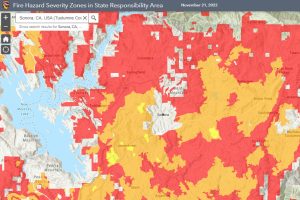
Sonora, CA – CAL Fire wants the public’s feedback on its new Fire Hazard Severity Zone Map (FHSZ) that was just released and will also host 57 public hearings statewide.
The last update to the map was in 2007. The new map reflects changes in fire hazards in unincorporated, rural areas. Overall, it shows increased fire hazards, reflecting California’s increase in wildfire occurrence and severity because of many factors, including a changing climate, according to CAL Fire.
“Ensuring Californians know the wildfire hazard in their area is critical to ensuring we all take the appropriate steps to prepare for wildfires,” said Chief Daniel Berlant, CAL FIRE Deputy Director of Community Wildfire Preparedness and Mitigation. “The updated map is the product of years of discussions and incorporates the latest science to provide a long-term outlook of an area’s wildfire hazard.”
This week begins a public comment period by the State Fire Marshal Office, between Friday, December 16, 2022, and February 3, 2023, for the regulatory adoption process to update the existing map that ranks California’s State Responsibility Area (SRA) based on the likelihood different areas will experience wildfire. To submit a written comment, email FHSZcomments@fire.ca.gov or mail:
Office of the State Fire Marshal C/O: FHSZ Comments California Department of Forestry and Fire Protection
P.O. Box 944246 Sacramento, CA 94244-2460
Many factors were considered in creating the map, such as fire history, existing and potential fuel (natural vegetation), predicted flame length, blowing embers, terrain, and typical fire weather for an area. These zones fall into the following classifications: moderate, high, and very high. To find out a property’s zone and additional map information, click here. According to CAL Fire, the model was reviewed and validated by members of the science community, as well as through outreach with various stakeholders, including insurance, building, fire, and local agencies.
“Making California safer from wildfires is our top priority, and my Department of Insurance will continue to work closely with the first responders at CAL Fire to better prepare our communities,” said Insurance Commissioner Ricardo Lara. “Public education about where current wildfire hazards exist is essential to reducing the threat to local communities and maintaining access to affordable insurance. I encourage Californians to ask questions in this public process and to learn more about the tools that exist to help communities and governments reduce their local risks.”
CAL Fire will also hold FHSZ public hearings in all 57 counties until the end of January, with one of the earliest hearings in Calaveras County tomorrow. Below are the hearing dates and times for the Mother Lode distributed by CAL Fire:
- Tuolumne County: 12/20/22 at 10:00 AM Hearing Location: Tuolumne County Fire Building 18440 Striker Ct, Sonora/Local Contact Person: Jon Andahl (209) 419-4425 jon.andahl@fire.ca.gov
- Calaveras County: 12/16/22 at 9:00 AM Hearing Location: San Andreas Community Hall 24 Church Hill Rd, San Andreas/Local Contact Person: Jon Andahl (209) 419-4425 jon.andahl@fire.ca.gov
- Mariposa County: 1/10/23 at 5:30 PM Hearing Location: Mariposa County Fire Department 4802 CA-140 Mariposa/Local Contact Person: Mike Keyser (559) 706-8824 michael.keyser@fire.ca.gov
Following the adoption of the SRA FHSZ Map, the State Fire Marshal will provide local agencies that meet FHSZ criteria with recommendations for local adoption and implementation.
CAL Fire provided this list of specifics regarding this process:
- This current revision only updates areas in California’s unincorporated, rural areas where wildfires tend to be frequent — called the “SRA” or “State Responsibility Area.” This does not include cities or large urban areas.
- This process does not change rules or requirements for homes or properties in these areas related to wildfire prevention, preparedness, and mitigation. The same requirements will remain regardless of whether a particular area is reclassified or not.
- The last Wildfire Hazard Severity Zone map was updated in 2007 and required an update. Using the best available science with academic researchers and others, this updated map reflects the impacts of a changing climate and includes a variety of other key factors.
- This is the beginning of a nearly two-month public process. These maps are being shared for your comments and questions during the regulatory process. A total of 57 public hearings will be held throughout the state with the goal of hearing from you.
- An online public toolkit and interactive map is available to help answer your questions. Take some time to explore your address, read the FAQs, learn about the process and where to turn. A hotline is also available to help answer your questions directly and to help increase access.

