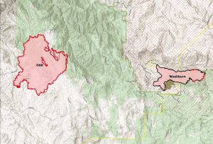
Mariposa, CA — The new size estimate on the Oak Fire this morning is 18,087 acres and there is 26 percent containment.
Officials are continuing to get an upper hand on the blaze. CAL Fire reports that crews are continuing to do structure defense, build lines and extinguish hotspots.
The was some precipitation reported in the area this morning and the humidity has been increasing.
Crews will continue to assess the damage throughout today. Incident command reports that at least 41 structures have been destroyed and three others are damaged. Officials are hoping there will be full containment by July 30.
The latest on evacuation orders and advisements from the Mariposa County Sheriff’s Office.
Evacuation Orders
• Lush Meadows north of Highway 49
• Bootjack north of Highway 49
• East of Bootjack Lane to McNally Rd
• North of Morning Star
• East of Lakeview Road / Plumbar Creek Road
• South of Highway 140
• Jerseydale
• Carlton Road from Morningstar to Silva Road including all side roads
• Triangle Road to E Westfall Road
• E Westfall Road to Oliver Creek Road
• Highway 140 from Triangle Road to Ponderosa Way
• Ponderosa Way from Hwy 140 to Feliciana Mountain Road and all side roads Sweetwater Ridge / Mine area
• Feliciana Mountain Road
• Ferguson / Apperson Mine Road area
• Savage Lundy Trail
• Hites Cove Road
• Footman Ridge area
• Devils Gulch area
Evacuation Advisement
-Hwy 140 from Colorado Road to Grosjean Road
-Oak Road from Hwy 140 to Yosemite Oaks
-Yosemite Oaks Rd from East Whitlock
-Allred Road from Morningstar to Hwy 49S
-Carlton Road from Silva Road to Hwy 49S and all side roads
-Indian Peak from Hwy 49S to Usona Road and all side roads
-East Whitlock from Hwy 140 to Yosemite Oaks Road
-Stumpfield Mountain Rd from Hwy 49S to the Madera County Line including all side roads
-East Westfall from Oliver Creek to Chowchilla Mountain Road
-Chowchilla Mountain Road from 49S to East Westfall
-Ponderosa Subdivision including: All of Chowchilla Mountain Road and all side roads
-All of Harris Cutoff Road and all side roads
-All of Harris Rd and all side roads
-5S25 and 4S04
-Hwy 49S from Chowchilla Mountain Rd to Harris Road on the (East Side)
-Chowchilla Mountain Roadside
-Hwy 49S from Triangle Road to the Madera County Line including all side roads
-This includes: Watt Road, Watt Road Extension, Harris Road, Kimble Road and all side roads
-Hwy 140 from Ponderosa Way to Briceburg both side of the roads
-Colorado from Hwy 140 to East Whitlock
-Rancheria Creek Road
-Davis Road
-Wilderness View Road
-Rumley Mine Road
-Grosjean Road from Hwy 140 to Foran Rd including all side roads
-Foran Road to East Whitlock
-East Whitlock from Foran to Hwy 140 including all side roads
-Devils Gulch to Signal Peak Area including Chowchilla Mountain Road
-Triangle Road from Hwy 49S to East Westfall
-Tip Top Road including all side roads
-Boyer Road including all side roads
-Mc Nally Road
-Brooks Road
-Woodland Drive
A Fire Advisement is NOT an evacuation Order, it is simply to advise residents in the area of the potential need to evacuate should conditions change. Allowing those in the affected area to plan and prepare.

