
Yosemite, CA — A total of 16 wildland fires were sparked by lightning last week in Yosemite National Park with most in the wilderness high country, but some pose a threat to public safety.
Park officials report that fire managers have been assessing all blazes for an appropriate response. They detail, “Due to the risk of visitor safety and park values the 10-acre King Fire, east of Glacier Point, is being suppressed in the Illilouette Creek drainage and is being controlled by hand crews and helicopters.” It is 50-percent contained.
Three fires are out. They include the Harden which was contained at 25 acres, the Pothole at an acre, and the Ridge at 10 acres. The remaining fires are burning in high elevation areas located in wilderness ranging from 7,000 to 9,700 feet. Park fire officials have concerns as sizzling heat with record temperatures throughout the region are forecast by the National Weather Service through next week, as reported here.
Park officials advise that Yosemite is a “fire-adapted ecosystem” with an overall managing strategy to provide for the “safety of employees and public, as well as protect and enhance natural and cultural resources.”
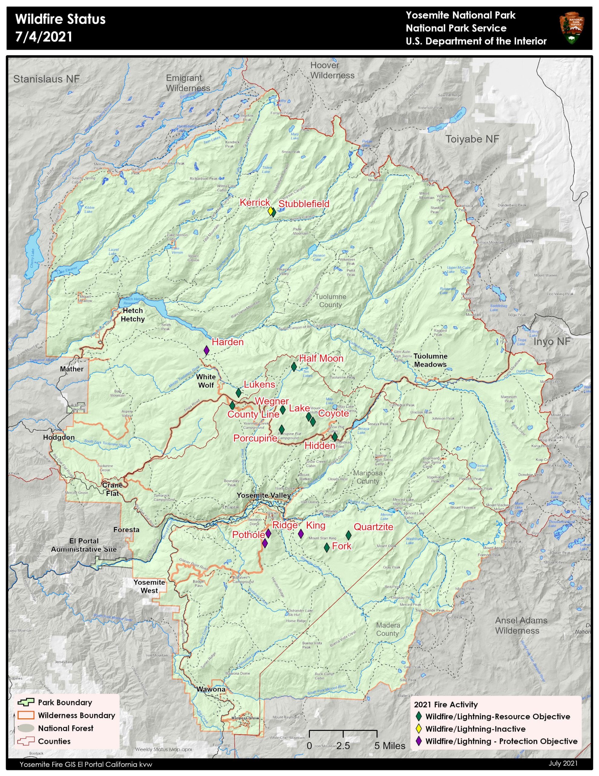
Park officials provided the below updates on 15 of the fires (Kerrick not included) :
King
Location: South of Nevada Falls, north of Mount Starr King. 7220 elevation.
Discovery Date: June 29, 2021 Size: 10 acres
Containment: 50% Strategy: Suppression
Cause: Lightning
Quartzite
Location: West of Quartzsite Peak. 8781 elevation.
Discovery Date: June 29, 2021 Size: .30 acre
Containment: 0% Strategy: Monitor
Cause: Lightning
Harden
Location: North of Harden Lake, south of Hetch Hetchy. 6665 feet elevation.
Discovery Date: July 1, 2021 Size: .25 acre
Containment: Out 7/4/2021 Strategy: Suppression
Cause: Lightning
Stubblefield
Location: Northern end of Yosemite NP, near Stubblefield and Kerrick canyons. 8000 elevation.
Discovery Date: June 28, 2021 Size: .1 acre
Containment: 0% Strategy: Monitor
Cause: Lightning
Porcupine
Location: Northeast of Porcupine Campground, and Tioga Road. 8210 elevation.
Discovery Date: June 28, 2021 Size: .10 acres
Containment: 0% Strategy: Monitor
Cause: Lightning
Coyote
Location: Coyote Rocks, north of Tioga Road. 9742 elevation.
Discovery Date: June 28, 2021 Size: .1 acre
Containment: 0% Strategy: Monitor
Cause: Lightning
Hidden
Location: Northwest of Olmsted Point, Tioga Road. 9017 elevation.
Discovery Date: June 28, 2021 Size: .1 acre
Containment: 0% Strategy: Monitor
Cause: Lightning
County Line
Location: Near Yosemite Creek Campground Road. 8361 elevation.
Discovery Date: June 28, 2021 Size: .6 acres
Containment: 0% Strategy: Confine and Contain
Cause: Lightning
Lukens
Location: West of Lukens Lake, North of Tioga Road. 8243 elevation.
Discovery Date: June 28, 2021 Size: .2 acre
Containment: 0% Strategy: Confine and Contain
Cause: Lightning
Wegner
Location: East of Yosemite Creek Picnic Area and east of Tioga Road. 8256 elevation.
Discovery Date: June 28, 2021 Size: .25 acre
Containment: 0% Strategy: Monitor
Cause: Lightning
Half Moon
Location: West of Ten Lakes near Half Moon Meadow. 8256 elevation.
Discovery Date: June 28, 2021 Size: .1 acre
Containment: 0% Strategy: Monitor
Cause: Lightning
Pothole
Location: South of Glacier Point Road. 7885 elevation.
Discovery Date: June 28, 2021 Size: .1 acre
Containment: Out 7/4/2021 Strategy: Suppressed
Cause: Lightning
Fork
Location: 1 mile southeast of Mt. Starr King. 8500 elevation.
Discovery Date: June 28, 2021 Size: .3 acres
Containment: 0% Strategy: Confine and Contain
Cause: Lightning
Ridge
Location: South of Glacier Point Road, across from Sentinel Parking area. 8000 elevation.
Discovery Date: July 3, 2021 Size: .10 acre
Containment: Out 7/4/2021 Strategy: Confine and Contain
Cause: Lightning
Lake
Location: West slope of Mt Hoffman. 9000 elevation.
Discovery Date: July 3, 2021 Size: .10 acre
Containment: 0% Strategy: Confine and Contain
Cause: Lightning