Update: Fires Creating Smoke And Travel Troubles For Yosemite
Update at 7:40 p.m.: The Railroad Fire is burning in the Sierra National Forest south of Fish Camp in Madera County. Forrest fire officials report that the fire has jumped to 1,000 acres. The communities of Sugar Pine and Fish Camp have been evacuated, which totals about 50 homes. Additionally, a hazard alert has been posted for the community of Wawona due to the fire issuing a low threat potential for evacuation. There are a total of nearly 100 homes threatened, according to forest officials. Currently, there are 200 fire personnel on scene. There is no containment and what sparked the blaze is under investigation. Additionally, a hazard alert has been posted for the community of Wawona due to the fire issuing a low threat potential for evacuation.
Original Post at 5:24 p.m.: Yosemite, CA – Fire activity in and around Yosemite National Park has caused a stretch of highway to be shut down and an explosion in acreage.
Highway 41 is closed between Tenaya Lodge and Oakhurst due to the Railroad Fire that broke out around 1p.m. and is 40 acres burning in the Sierra National Forest south of Fish Camp in Madera County. The flames are creating travel problems for Yosemite. Forest fire officials say there is no access to the park from Highway 41 from Fish Camp, Oakhurst or Fresno. Visitors are asked to use Highway 49 to Mariposa, then Highway 140 into Yosemite. It is uncertain as to when the road will reopen but the south entrance to Tenaya Lodge remains open at this time.
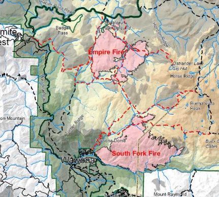
Flames from the Empire Fire burning 3/4 mile south of Glacier Point Road, which is now closed due to the flames, saw a hike of nearly 1,400 acres to 4,125 with 40 percent containment. Fire personnel climbed from 35 to 75 with four helicopters working the fire from above. Park Fire officials report that due to a very dry air mass, fire activity increased Monday on the eastern flanks of the fire burning in heavy pockets of down and dead vegetation while the west and northwest flanks of the fire are contained. Currently fire crews are implementing a perimeter control strategy for the north, west, and southern flanks of the fire to protect Bridalveil Campground, Yosemite Ski and Snowboard Area, Yosemite West subdivision, Wawona Road (Highway 41), and Glacier Point road. The strategy for the east flank, according to fire officials, is to steer the fire east, deeper into the wilderness where there is sparse vegetation and natural granite barriers to help slow the spread and limit smoke production.
Additionally, the community of Wawona keeps a nervous eye on the South Fork Fire after an earlier evacuation had forced residents from their homes. The fire has grown in acreage overnight to 5,724 but remains 44 percent contained. The personnel has increased from 101 to 128 with four helicopter overhead. Park fire officials report that the north flank of the fire was the most active on Monday burning into heavy pockets of fuel. The south and west flanks of the fire have been contained but some smoke will be visible as logs and brush burn in the interior. Crews will continue to patrol and monitor the flanks closest to the community of Wawona and Mariposa Grove.
Park officials warn that smoke and poor air quality will persist at least through the first part of September. Click here for an earlier story listing all of the road, trail and campground closures as a result of these fires.