Latest On Yosemite Lightning Fires
Sponsored by:
Yosemite, CA — Officials continue to monitor some lightning-caused fires in Yosemite National Park.
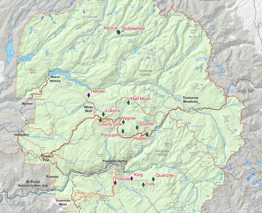
The biggest incident that officials are actively suppressing is the King Fire south of Nevada Falls and north of Mount Starr King. It is eight acres and five percent contained. A total of 14 lightning-caused fires are burning in the park. Most are well under an acre in size.
King
Location: South of Nevada Falls, north of Mount Starr King. 7220 elevation.
Discovery Date: June 29, 2021 Size: 8 acres
Containment: 5% Strategy: Suppression
Cause: Lightning
Quartzsite
Location: West of Quartzsite Peak. 8781 elevation.
Discovery Date: June 29, 2021 Size: 0.30 acre
Containment: 0% Strategy: Monitor
Cause: Lightning
Harden
Location: North of Harden Lake, south of Hetch Hetchy. 6665 feet elevation.
Discovery Date: July 1, 2021 Size: 0.25 acre
Containment: 0% Strategy: Suppression
Cause: Lightning
Stubblefield
Location: Northern end of Yosemite NP, near Stubblefield and Kerrick canyons. 8000 elevation.
Discovery Date: June 28, 2021 Size: 0.1 acre
Containment: 0% Strategy: Monitor
Cause: Lightning
Porcupine
Location: Northeast of Porcupine Campground, and Tioga Road. 8210 elevation.
Discovery Date: June 28, 2021 Size: 0.10 acre
Containment: 0% Strategy: Monitor
Cause: Lightning
Coyote
Location: Coyote Rocks, north of Tioga Road. 9742 elevation.
Discovery Date: June 28, 2021 Size: 0.1 acre
Containment: 0% Strategy: Monitor
Cause: Lightning
Hidden
Location: Northwest of Olmsted Point, Tioga Road. 9017 elevation.
Discovery Date: June 28, 2021 Size: .1 acre
Containment: 0% Strategy: Monitor
Cause: Lightning
County Line
Location: Near Yosemite Creek Campground Road. 8361 elevation.
Discovery Date: June 28, 2021 Size: 0.1 acre
Containment: 0% Strategy: Confine and Contain
Cause: Lightning
Lukens
Location: West of Lukens Lake, North of Tioga Road. 8243 elevation.
Discovery Date: June 28, 2021 Size: 0.2 acre
Containment: 0% Strategy: Confine and Contain
Cause: Lightning
Wegner
Location: East of Yosemite Creek Picnic Area and east of Tioga Road. 8256 elevation.
Discovery Date: June 28, 2021 Size: 0.25 acre
Containment: 0% Strategy: Monitor
Cause: Lightning
Half Moon
Location: West of Ten Lakes near Half Moon Meadow. 8256 elevation.
Discovery Date: June 28, 2021 Size: 0.1 acre
Containment: 0% Strategy: Monitor
Cause: Lightning
Pothole
Location: South of Glacier Point Road. 7885 elevation.
Discovery Date: June 28, 2021 Size: 0.1 acre
Containment: 0% Strategy: Suppressed
Cause: Lightning
Fork
Location: 1 mile south of Ostrander Lake along Horse Ridge. 8500 elevation.
Discovery Date: June 28, 2021 Size: 0.3 acres
Containment: 0% Strategy: Confine and Contain
Cause: Lightning
Ridge
Location: South of Glacier Point Road, across from Sentinel Parking area. 8000 elevation.
Discovery Date: July 3, 2021 Size: 0.10 acre
Containment: 0% Strategy: Confine and Contain
Cause: Lightning
Lake
Location: West slope of Mt Hoffman. 9000 elevation.
Discovery Date: July 3, 2021 Size: 0.10 acre
Containment: 0% Strategy: Confine and Contain
Cause: Lightning