Two tropical storm systems near each other could wind up shielding the Carolinas from damage
Two tropical storm systems near each other could wind up shielding the Carolinas from damage
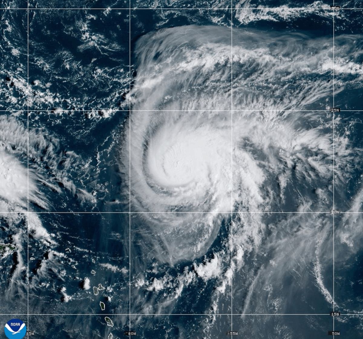
NEW YORK (AP) — An unusual interaction of two tropical storm systems — maybe even a rare dance — could happen soon in the Caribbean. If it does, it would lessen the mess and maybe even shield the Carolina coast from a wet embryonic tropical system chugging that way.
A still unnamed and developing tropical depression — likely to become Imelda — is heading toward the South Carolina/North Carolina state line and has the potential to bring damaging heavy rains, especially if it stalls and keeps pouring for awhile.
The depression off the coast of Cuba and heading to the Bahamas is threatening enough and could hit early next week, so Carolinas residents need to be aware, especially of rain and flooding possibilities, National Hurricane Center Director Michael Brennan said. It is forecast to go due north.
“People need to pay attention,” Brennan said Friday. “This is a scenario where we could have a system again develop and make landfall within just two or three days.”
But big bad Humberto may come to the rescue.
The stronger, further east and older storm may get close enough to Imelda-to-be and start to interact. There are several ways they could interact. Humberto, which reached major hurricane status late Friday afternoon, could tug the smaller storm to the east. Humberto, which is not forecast to hit the U.S. mainland, could pull the depression apart. The two could merge into one even larger storm, University of Miami hurricane researcher Brian McNoldy said.
And finally is the most rare interaction, usually seen more in the Pacific: They could dance together, swirling around a spot in the middle. This was first seen more than 100 years ago and is called the Fujiwhara Effect for the Japanese scientist who discovered it. Two years ago, tropical storms Philippe and Rina did a little dance much farther away from the United States, McNoldy said.
“It seems like it might be somewhat less likely than it may have looked like a couple of days ago, but right now the two systems are, you know, more than a thousand miles, almost 1,100 miles apart from each other,” Brennan said Friday. “So they really have to be within about 800 miles of each other to start to have that type of interaction.”
Most interactions will likely pull the younger smaller system to the east and away from the coast and maybe even pull it apart, McNoldy said. And the most likely of the bunch is that Humberto gives Imelda-to-be a gentle tug to the east, pulling it away from the coast, he said.
“I wish they were closer,” McNoldy said. “Not only would it be really neat to watch, but it would fling future Imelda out to sea.”
“The key is Humberto’s movement. Will it go further west and speed up, shrinking the gap between the two systems?” McNoldy said: “Humberto’s more in charge of what’s going to happen.”
In a hurricane such as Humberto, the air rises up the middle and spreads out like a mushroom and then eventually sinks. It is that sinking air that may hamper Imelda-to-be, State University of New York at Albany atmospheric scientist Ryan Torn said.
This is so unusual that the National Oceanic and Atmospheric Administration is doing extra airplane missions to measure the atmospheric conditions between the two systems, Torn said.
This type of situation usually doesn’t happen because there is sort of a natural spacing out between developing storm systems that chug west off Africa, Torn said.
___
The Associated Press’ climate and environmental coverage receives financial support from multiple private foundations. AP is solely responsible for all content. Find AP’s standards for working with philanthropies, a list of supporters and funded coverage areas at AP.org.
By SETH BORENSTEIN
AP Science Writer