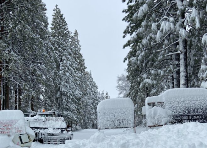
The Winter Storm Warning issued for Mariposa County above 2,000 feet and the Blizzard Warning for Yosemite National Park, will expire at 4 PM this afternoon.
Total snow accumulations above 2,000 feet, range from half-a-foot to as much as six feet.
Winds may continue to gust as high as sixty to seventy-five mph. Gusty winds could bring down tree branches. The dangerously cold wind chills, as low as thirty below zero, could cause frostbite on exposed skin in as little as ten minutes.
Travel remains very difficult to impossible. The hazardous conditions will impact the morning commute.
Travel should be restricted to emergencies only. If you must travel, keep an extra flashlight, food, and water in your vehicle in case of an emergency. If you get stranded, stay with your vehicle.
A Hard Freeze Warning for the Mother Lode, has been issued for Thursday from 2 AM until 8 AM.
Sub-freezing temperatures range from twenty-four to thirty degrees.
A Freeze Warning for the northern San Joaquin Valley, will be in effect on Thursday from 2 AM until 8 AM. A Freeze Warning has also been issued for the central San Joaquin Valley tomorrow from 2 AM until 9 AM.
Sub-freezing temperatures will range from twenty-seven to thirty-two degrees.
Additionally, the National Weather Service has issued a Freeze Watch for the central San Joaquin Valley from late Thursday night through Friday morning.
Sub-freezing temperatures as low twenty-eight degrees are forecast.
Frost and freeze conditions will kill crops, other sensitive vegetation and possibly damage unprotected outdoor plumbing.
Take steps to protect tender plants from the cold. To prevent freezing and possible bursting of outdoor water pipes they should be wrapped, drained, or allowed to drip slowly. Those that have in-ground sprinkler systems should drain them and cover above-ground pipes to protect them from freezing.