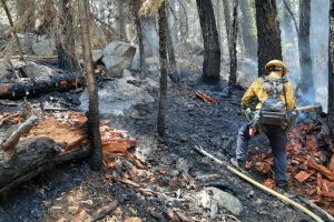
El Dorado County, CA — The Caldor Fire burning in El Dorado County is now burning over 65,000 acres.
There is no containment. It is creating smoky skies throughout the Mother Lode region Many areas around Grizzly Flat in El Dorado County remain under an evacuation order, and parts of Amador County are now under an evacuation warning. Yesterday the most significant growth was on the northeast corner, south of Highway 50. All forest roads and trails are now closed within the El Dorado National Forest. Crews are facing steep and challenging terrain. 6,900 structures are threatened and two civilians have reported injuries.
Below is the latest information regarding evacuations:
AMADOR COUNTY -WARNINGS
- Shenandoah Road at the Amador County line west through the River Pines community, continuing west on Shenandoah Road to Ostrom Road.
- Southon Ostrom Road to Jibboom Street, West on Jibboom Street to Fiddletown Road. East on Fiddletown Road to Hale Road.
- South on Hale Road to ShakeRidge Road.
- East on Shake Ridge Road to Charleston Road.
- South on Charleston Road to the intersection of Charleston Road and Rams Horn Grade.
- Due east to Highway 88 at Tiger Creek Road.
- Tiger Creek Road east to Salt Springs Reservoir Road.
- East on Salt Springs Reservoir Road to the east end of the Salt Springs Reservoir.
- Due north from the east end of Salt Springs Reservoir to Highway 88.
EL DORADO COUNTY – ORDERS
- Grizzly Flat: The areas on Grizzly Flats Road east of Kendra Way into Grizzly
- Flats Proper. The areas of Diamond Railroad Grade, Old School House, Sweeney Road, Caldor Road, and steely Ridge.
- Grizzly Flats Road east of four corners in somerset into Grizzly Flats Proper.
- The areas of Myers Lane, Varmet Ridge Road, Rodwell Canyon Road, Snowbird Lane, and Mehwald Lane.
- East of Sly Park Road between Highway 50 and Mormon Emigrant Trail to Ice House Road. This includes the communities of Pacific House and Fresh Pond.
- North of Highway 50, east of Forebay Road to Ice House Road.
- Intersection of Perry Creek and Hawk Haven, the East side of Fairplay Road from Perry Creek South to Cedarville Road. This includes Slug Gulch, Omo Ranch, and all roads off of Slug Gulch and Omo Ranch.
- All roads off of Omo Ranch from Cedarville Road to Hwy 88.
- The area between Highway 88 and Mormon Emigrant Trail
- South of Highway 50 from Snows Road to Ice House Road.
- Between Highway 50 and Slab Creek from Snows Road to Ice House Road.
- South of Highway 50 from Ice House Road to Silver Fork Road. This includes the community of Kyburz.
- North of Highway 50 from Ice House Road to Silver Fork Road to include Ice House Reservoir, Union Valley Reservoir, and Loon Lake.
EL DORADO COUNTY EVACUATION WARNINGS:
- North of Slab Creek to Wentworth Springs Road between Sand Mountain and Loon Lake.
- Mosquito Road from the bridge North to include the Community of Swansboro.
- North of Highway 50 to Slab Creek between Smith Flat and Snows Road.
- South of Highway 50 to Pleasant Valley between Smith Flat and Snows Road, and North of Pleasant Valley between Holm and Newtown.
- South of Pleasant Valley between Bucks Bar Road and Newtown Road, East of Bucks Bar Road to Mt Aukum Road.
- Southwest of Bucks Bar Road to Ladies Valley Road including the community of Outingdale, Ant Hill Road, Perry Creek Road and Sand Ridge between Ladies Valley Road and Bucks Bar Road.
- East of Mt Aukum Road (E16) from Bucks Bar Road to Omo Ranch Road. North of Omo Ranch Road to the intersection of Omo Ranch Road and Fairplay Road.
- South of Omo Ranch to the El Dorado County Line between Mt Aukum Road (E16) and Fairplay Road to include Coyoteville Road, Cedar Creek and all tributary roads.
- North of Slab Creek to Wentworth Springs Road between Sand Mountain and Loon Lake.
- Mosquito Road from the bridge North to include the Community of Swansboro.
- North of Highway 50 to Slab Creek between Smith Flat and Snows Road.
- South of Highway 50 to Pleasant Valley between Smith Flat and Snows Road, and North of Pleasant Valley between Holm and Newtown.
Evacuation Centers:
- Shelter open with availability
El Dorado Community Center
6139 Pleasant Valley Road
El Dorado, CA - Shelter Full
Cameron Park CSD
2502 Country Club Drive
Cameron Park, CA - Shelter Closed
Diamond Springs Fire Hall
3734 China Garden
Diamond Springs, CA
Animal Evacuation Centers:
- El Dorado County Animal Services: Call (530)-621-5795 (Small animals)
- Large Animal Shelter Amador County Fairgrounds 18621 Sherwood St., Plymouth (530)621-5795 or (530)647-6227

