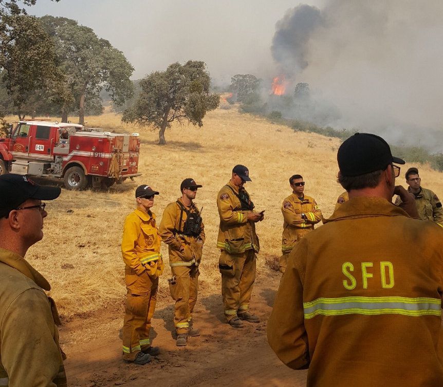
Update: Detwiler Fire At 76,000 Acres And 40-Percent Containment
Update at 3:45pm: Sgt. Andrea Benson of the sheriff’s office reports that all Detwiler Fire related evacuation warnings and advisories have been lifted in Tuolumne County.
Update at 1:20pm: Evacuation orders are being lifted for more communities impacted by the Detwiler Fire. The below areas are no longer under an evacuation order, but still remain under an evacuation advisory:
-Hwy 49 North from the town of Coulterville to Crown Lead Rd including all side roads Hwy 132 and all side roads
-J132- From Hwy 49 North to Lower Dog Town Rd (Dog Town Rd remains closed)
-Downtown Coulterville Buckeye Rd
-Old Hwy and all side roads(Yaqui Gulch remains closed)
-W. Whitlock and all side roads (Mt. Bullion Ridge Rd remains closed)
-E. Whitlock and all side roads
-Colorado and all side roads
-Sherlock Rd and all side roads
-The following roads on Hwy 140: Martin Rd, Bumguardner Mt. Rd, Paso Del Oso, Hummingbird Ln, Grosjean Rd, Lakeview Rd
The following roads will remain closed in the above lifted area
Yaqui Gulch and all side roads – Closed from Old Hwy to Hwy 140
Hwy 49N- Closed from 1 mile North of Bear Valley to Crown Lead Rd
Greeley Hill Rd- Closed from Lower Dog Town to Bowers Cave
Original story posted at 7:40am: Mariposa, CA — CAL Fire reports that 4,756 firefighters are assigned to the Detwiler incident today.
The fire remains 40-percent contained and is around 76,000 acres. 63 homes have been destroyed, 67 outbuildings and one commercial building. In addition, 13 more homes have received damage, as well as eight outbuildings. What ignited the Detwiler Fire remains under investigation.
Last night firefighters continued to complete and improve direct and secondary fire lines. The fire is still making minimal uphill runs in tall grass and chaparral. Weather is expected to remain above 100 degrees today with low humidity.
Click here for a recap from yesterday.
Evacuations:
These areas will still remain under advisory.
French Camp Rd
Fournier Rd
Mykleoaks Rd
West Whitlock from 49N to Whitlock Gap (Three miles from Hwy 49 N)
Hwy 140 from Hornitos Rd to Elizabeth Lane
All evacuations on Hwy 140 between Elizabeth Ln to approximately one mile west of the town of Mariposa, remain under an Evacuation Order.
Evacuations lifted on July 22, 2017 at 6:00 PM
Old Hwy from Hwy 49 South to Totokon Rd and all side roads
Old Hwy from Guadalupe Fire Rd to Hwy 140 (Catheys Valley)
Bear Valley Rd
Hunters Valley Rd
Hunters Valley Mt. Access Rd
Detwiler Rd
Cotton Creek Rd
Evacuation Orders
South County: Mt Bullion Ridge Rd, Old HWY South from Totokon to Guadalupe Fire Rd and all side roads, Buckeye Rd. to Ben Hur Rd. and ALL side roads, HWY 140 from 1 Mile east of Mariposa to East Whitlock Rd. and ALL side roads, East Whitlock Rd from HWY 140 to Colorado Rd and All side roads to the West, , Colorado Rd. from E. Whitlock to Rancheria Creek Rd and ALL side roads, All of Rancheria Creek Rd. ALL of Sherlock Rd, ALL of Telegraph Rd, River Rd from Briceburg to Northfork Falls ,CYA Camp Rd, Mt. Bullion Cuttoff Rd- From Hwy 140 to 72a and Princeton Rd- From 49N to 72b.
North County: HWY 49-N from Schilling Rd. to Oakridge Rd. and ALL feeder roads, HWY 132 from HWY 49-N to Windy Point, the town of Coulterville, Dogtown Rd. from Greeley Hill Rd. to Texas Hill Rd., ALL of Texas Hill Rd., Schilling Rd from HWY 49-N to Texas Hill Rd, Greeley Hill Rd. from Dogtown Rd. (Coulterville) to Dogtown Rd. near Bowers Cave. All roads between Greeley Hill Rd, Texas Hill Rd. Bull Creek Rd from Greeley Hill Rd to the Merced River, Old Yosemite Rd to the Five Corners intersection. West Whitlock from Whitlock gap to East Whitlock.
Evacuation Advisories NORTH COUNTY: HWY 49N from Oakridge Rd. to the County Line. All roads north of Greeley Hill Rd. to the Mariposa County line, to include Dexter Rd., Cueno Rd., Smith Station Rd. to HWY 120 and ALL feeder roads, Buck Meadows Rd. north of Greeley Hill Rd. to HWY 120, Old Yosemite Rd and Bull Creek Rd.
SOUTH COUNTY: Hwy 49-S from Ben Hur Rd to Indian Peak Rd and ALL feeder roads, Ashworth to Silver Lane and ALL feeder roads, Silver Bar to Ashworth and ALL feeder roads, Indian Peak to Oak Grove Rd and ALL feeder roads, Oak Grove Rd from Miwuk Rd to Oak Grove School Rd and ALL feeder roads, Detwiler Rd, Hunters Valley Rd, Hunters Valley Access Rd, Cotton Greet Rd, Allred Rd from 49S to Morningstar Lane and ALL feeder roads, Morningstar Lane to Carlton Rd and ALL feeder roads, Carlton Rd to Silva Rd and ALL feeder roads, Silva Rd to Hwy 49 South and ALL feeder roads, Bear Valley Rd- All homes, Hornitos Town Area, HWY 140 from Briceburg to E. Whitlock, Colorado Rd from HWY 140 to Rancheria Creek Rd., Oak Rd and Yosemite Oak Rd and all of Mariposa Town, 49-N from Mariposa to Fremont Fort, Mt Bullion Cuttoff Rd-from 49-N to 72b, School Ln, Rd 72A, Princeton Rd-from 49-N to 72b, Pendola Gardens, Old Toll, Corbett Creek Rd, Mt. Ophir, Hornitos Rd, Mt Gaines, No.9 Rd and Ben Hur Rd from Hwy 49 S. to Buckeye, French Camp Rd, Fournier Rd, , Mykleoaks Subdivision, W.Whitlock from 49-N to Whitlock Gap, HWY 140 from Hornitos Rd to Elizabeth Ln. Old HWY South from 49 S to Totokon, Old HWY South from 49 from Guadalupe Fire Rd to School Lane,
Evacuation Advisories – Tuolumne County Smith Station Rd. to HWY 120 and ALL feeder roads.
End Day 8 report
Detwiler Fire Starts
Detwiler Fire Day 2
Day 3
Day 4
Day 5
Day 6
Day 7
Day 8 (see above)
Day 9
Dewilter Fire Timeline Overview