Two Yosemite Lightning Strike Fires Grow
Yosemite, CA – While ten fires have been contained, two have grown in size.
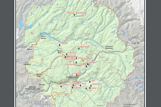
Thunderstorms with lightning blew through the park from June 28 to July 2 ignited 19 fires. Fire managers detail, “Ten fires have been contained due to location and spread potential.” There are six remaining fires currently being monitored all in the high elevation areas ranging from 7,000 to 9,700 feet. Two of the fires have seen significant growth. The Lukens Fire, west of Lukens Lake and north of Tioga Road has jumped from 1.4 acres to 450, and the County Line Fire, near Yosemite Creek Campground Road, from 6 acres to 170 in about a week, as reported here. Park fire officials relay that both blazes are being suppressed using roads and trails to contain and confine, with additional burning to secure these fires into the Wolf and Blue Jay fire footprints from 2020.
Traffic may be impacted on Highway 120/Tioga Road with one-way traffic from White Wolf Junction to Mc Swain Summit as fire crews and equipment will be active in that area. Park Fire officials provided these details on twelve of the blazes:
King
Location: South of Nevada Falls, north of Mount Starr King. 7220 elevation.
Discovery Date: June 29, 2021 Size: 10 acres
Containment: 100% Strategy: Suppression
Cause: Lightning
Quartzite
Location: West of Quartzsite Peak. 8781 elevation.
Discovery Date: June 29, 2021 Size: .5 acre
Containment: 0% Strategy: Monitor
Cause: Lightning
Stubblefield
Location: Northern end of Yosemite NP, 2000 feet from Pacific Crest Trail (mile marker 982), no threat to trail. 8000 elevation.
Discovery Date: June 28, 2021 Size: 2 acres
Containment: 0% Strategy: Monitor
Cause: Lightning
Porcupine
Location: Northeast of Porcupine Campground, and Tioga Road. 8210 elevation.
Discovery Date: June 28, 2021 Size: 3.7 acres
Containment: 0% Strategy: Monitor
Cause: Lightning
Hidden
Location: Northwest of Olmsted Point, Tioga Road. 9017 elevation.
Discovery Date: June 28, 2021 Size: .1 acre
Containment: 0% Strategy: Monitor
Cause: Lightning
County Line
Location: Near Yosemite Creek Campground Road. 8361 elevation.
Discovery Date: June 28, 2021 Size: 170 acres
Containment: 60% Strategy: Confine and Contain
Cause: Lightning
Lukens
Location: West of Lukens Lake, North of Tioga Road. 8243 elevation.
Discovery Date: June 28, 2021 Size: 450 acres
Containment: 0% Strategy: Confine and Contain
Cause: Lightning
Wegner
Location: East of Yosemite Creek Picnic Area and east of Tioga Road. 8256 elevation.
Discovery Date: June 28, 2021 Size: .25 acre
Containment: 0% Strategy: Monitor
Cause: Lightning
Half Moon
Location: West of Ten Lakes near Half Moon Meadow. 8256 elevation.
Discovery Date: June 28, 2021 Size: .1 acre
Containment: 0% Strategy: Monitor
Cause: Lightning
Fork
Location: One mile southeast of Mount Starr King. 8500 elevation.
Discovery Date: June 28, 2021 Size: 12 acres
Containment: 100% Strategy: Confine and Contain
Cause: Lightning
Lost
Location: Northeast Starr King Meadow. 8700 elevation.
Discovery Date: July 6, 2021 Size: .25 acre
Containment: 100% Strategy: Suppression
Cause: Lightning
Snow
Location: May Lake Trailhead, near Tioga Road. 8600 elevation.
Discovery Date: July 14, 2021 Size: .1 acre
Containment: 100% Strategy: Suppression
Cause: Lightning